The Beira Lake is not an unfamiliar place to most of us, but very few may be aware of its history – from its beginning in the 16th century. With the Government’s plans to develop this lake into a tourist zone, we decided to enlighten you about this famous lake and also clear out any misconception you may have had about the origin and history of the lake.
I had been witnessing the Beira Lake daily for over 30 years since my office, Lake House is just one corner of the lake. So, it was a part and parcel of my daily life as I saw many changes of the lake from time to time as well as its environmental impact such as sewage smell, dying of fish and rapid crocodile population.
I thought that Colombo’s Beira Lake was a natural lake unlike the Kandy Lake which is man-made, until I read a reference to this lake recently, in a translation of a book by a Portuguese priest, Father Fernao de Queyroz. Father Queyroz says, “When Vijaya Bahu laid siege to Colombo in 1522, the Portuguese captain, Lopo de Britto pursued the attackers, killing and wounding them, till they reached a stream, which was afterwards dammed into a lake for the better fortification of the city.”
Distributary
This ‘stream’ was a distributary of the Kelani Ganga, and was known as Kolon Ganga. A distributary is a stream or small river that flows out of the main river deltas.
This small river would have branched off the Kelani Ganga at Sedawatta, flowed along the low-lying land past Dematagoda and into the sea at a point North of the present harbour. Kolonnawa, a town to the South of the Kelani Ganga is known by that name because the Kolon Ganga flowed through the area.
At the mouth of the Kolon Ganga was a small port, Kolontota, like Gintota at the mouth of the Gin Ganga, North of Galle. It was at Kolontota that the Portuguese landed in 1505. Even then it was a busy trading port, much used by Arabs. The dam that the Portuguese built across the Kolon Ganga is gone, but its memory lives on, in a street name, Dam Street in Colombo Central.
 The Dutch period painting of the Beira Lake (courtesy-internet)
|
Father Queyroz gives us more information about the lake. In 1555, the Portuguese built some houses making Kolontota “a city surrounded by a ‘Calapana’ (a lake) nearly three leagues and a half in length.” (A league is about three miles). The writer says that one had to cross the water to get to the city and that in some places the water was up to a man’s waist.
In 1578, Mayadunna, the King of Sitawaka brought his army and camped on the bank of the lake. He wanted to cut off food supplies to the Portuguese, which were brought in boats, starve them and force them to surrender. He attempted to drain the lake but failed.
His son, Rajasingha besieged Colombo a few times and drained the lake twice by cutting canals, one of these is the San Sebastian canal in Maradana. The Portuguese did not surrender.
Islands in the lake
There were, at that time, many islands in the lake. Don Jeronimo de Azevedo, the Portuguese Captain General had a house in one island. He came there to relax, enjoying the cool breeze blowing across the lake. One island was large enough to have 600 coconut trees and a whole village. The present Polwatta, the suburb behind ‘Temple Trees’, the President’s House, must be part of that island.
The lake was the scene of many battles; first between the Sinhalese and the Portuguese and later between the Portuguese and Dutch and the Dutch and the British. In 1656, the Dutch came in boats via the Kelani Ganga and attacked the Fort and the houses outside the Fort. For six months, they kept on firing their guns.
The wall surrounding the Fort was broken down and the churches, houses and store-houses inside the Fort were reduced to rubble. After seven months of fighting, the Portuguese surrendered and with that, their rule in Sri Lanka ended.
The Dutch who now occupied the Fort didn’t re-build the wall. Instead they built a fence-stockade – on higher ground some distance away from the old wall. The result – the Fort became smaller and the lake larger. The low-lying land outside the Fort was flooded and the lake now extended to Kayman’s gate in the present day Pettah.
This part of the lake was infested with crocodiles, hence the name Kayman. It is a word for crocodile in Portuguese and Spanish. The enlarged lake was connected by canals “With the Kelani Ganga to the North and with Bolgoda Lake and Panadura Ganga to the South.” The town outside the Fort was called Aut Stad. Today’s Pettah is the Aut Stad.
The Dutch controlled Colombo and low-country for 140 years from 1656.
The British who were now in the Indian Ocean started attacking the Dutch in 1795. They too came across the lake. The Dutch fought back, but it was not a long battle. On February 7, 1796, the Dutch surrendered and the period of Dutch rule in the low-country ended.
Slave Island
When the British took control of Colombo, there were small islands in the lake. Slave Island was one such island and it was called by that name because the slaves who worked in Dutch houses were sent there for the night. The Dutch had grown cinnamon on the island. The Captain’s Garden, the slightly high ground between Fort and Maradana Railway Stations, where there is a Hindu Kovil now, was an island then.
In that island was a fresh water well that supplied drinking water to the officers and residents in the Fort.
From accounts left by army officers, by residents and visitors, we learn that in the early days of British rule, the “blue lake of Colombo” was a beautiful place, that many streams fed the lake and it extended up to four or five miles in a North Easterly direction. The lake was an ideal place for boating. Those residing on the banks of the lake went by boat to their work places in the Fort. There were frequent parties and sporting events on the bank.
The Colombo Municipal Council was established in 1865. About 20 years later, land by the lake began to be sold to commercial companies. They wanted land on the lake front because it was easy to transport their goods – barrels of coffee and bales of cinnamon and spices – by boat to the harbour. The canal by Lake House on its left, is one canal along which boats went to the harbour.
Today, only names remain to tell us what and what areas were part of the lake or its shore. The land where St. Joseph’s College stands and the surrounding area was known as Suduwella – white sandy shore. There is still Municipal ward by that name. Today, there is not one square metre of white sand left of that once white sandy shore.
As the population of Colombo increased so did the garbage. Much of it went into the lake and the water got polluted. The garbage on the bank gave out a horrible stench and was the breeding ground of mosquitoes and flies. It was this stench and mosquito-fly menace that led to the closing of the school – Colombo Academy sited near the lake. It was re-opened in Cinnamon Gardens under a new name – Royal College.
Around 1980s, the water was so polluted with more and more buildings coming up on the waterfront and population increasing.
The selling of land on the lake front continued into the 1990. In the last two decades of the 20th century, hotels, banks and Government offices, came up on the banks of the lake, some five, six, storeys high. Now those going on the D.R. Wijewardene Mawatha or the Chittampalam A. Gardiner Mawatha hardly get a glimpse of the lake.
Water pollution
Only the part of the lake where the ‘Seema Malaka’ is can be seen closely to the Gangarama temple. Hotels, printing presses, food processing factories, beverage manufacturers and slums round the lake were diverting their polluted water into the lake. But, the major source of pollution was the raw sewage that was sent into the lake.
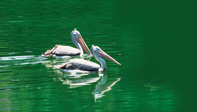
What was once an ornament to the city had by 1990s become a health hazard. Work on the restoration of the lake with World Bank aid started at the turn of the century. The lake was dredged, algae destroyed, algae eating fish introduced and underserved settlements by the lake, improved. However, the lake is also home to species of herons, storks, spot-billed pelicans, crocodiles, monitor lizards and various species of fish.
Since recently, the Beira Lake has been playing a major role in the Western Region Megapolis Project. Under the project, the Beira Lake is expected to be cleaned and developed with Singaporean assistance and private sector involvement.
Lined with many large warehouses, reminiscent of its past when tea used to be transported to the harbour on barges via the port access canal, the lake now is very quiet with many of the warehouses having been abandoned. With maximum length of 1 mile, the lake has been home to Colombo Rowing Club for over 140 years. The Sri Lanka Exhibition and Convention Centre is on the waterfront while the tallest tower in the country, the Lotus Tower has been built on the bank of the lake giving a scenic setting to the landscape of the Colombo city.
It was only after 1927 that the lake began to be called Beira Lake. That year, the word Beira appeared on the map. Until then the lake was called Colombo Lake or just the lake. Beira – it is an unusual word. What does it mean? Beira is a Portuguese word. There is in Portugal a province called Beira. Beira is also the name of a coastal town in Mozambique, once a Portuguese colony. It is interesting to find out how that village/town got that name.

The lake with towering new buildings in the Colombo city in the background

The Southwestern side of the lake with the ‘Seema Malaka’ Temple in the middle

The Beira Lake with the Lotus Tower in the background

The lake is home to spot-billed pelicans