


The United Nations World River Day falls today (24). The United Nations declared the World River Day in 2005 to save the world’s river systems from deterioration resulting from the unscrupulous human activities.
Sri Lanka is blessed with 103 rivers fairly distributed over the country. The country receives high rainfall during North- East and South-West monsoons.
World history indicates that all human civilisation were promoted around river basins. Four civilisations: Mesopotamian, Indo Egyptian and Chinese civilisations considered to be world’s oldest civilisations developed along the main rivers such as Euphrates and Tigris, Indus, Nile and Hwang-Ho.
The first human settlements in Sri Lanka were established at the Mahaweli river (Mahavaluka Nadee), Malwathuoya river (Kadhamba Nadee), Kala Oya river (Gona Nadee), Kelani river (Kalyana Nadee), Walawe river (Vanvahini), Deduru Oya (Jujjara Nadee), Kirindi Oya (Kappakandara Nadee), Gal Oya (Galha Nadee) and Amban river (Kara Kara Nadee).
Contaminated water
There are more than 10,000 sources of contaminated water in the country’s 103 rivers. Many industries have been established close to rivers. According to the Environment Ministry, the Kelani river alone which is the main source of water for Colombo and the suburbs is polluted. Around 7,000 large and medium scale factories are operating in the Kelani river valley from Kaduwela to the Peliyagoda bridge. There are thousands of business establishments, hotels and private residences including slums discharging all sorts of waste in to the Kelani river. The situation in other major river systems is no different. Out of the country’s major river systems, the Mahaweli river is the largest river basin covering 1/5th of the land area of Sri Lanka. The total valley fed by Mahaweli is around 10,000 square Kilometres.
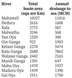 The 103 river basins cover the land extent of around 59,424 Km2 while the remaining area is covered by Jaffna peninsula and small costal basins including the islands of kayts and Kachativu. Twenty rivers have been designated as wet zone rivers, covering 12,676 Km2 of the country’s landscape. The other 83 river basins located in dry zone represent the 80 percent of the country’s land area. Thirty-six rivers have got catchment area of 371 Km2. Among them, seven major rivers: Kelani, Kalu, Benthara, Gin, Nilwala, Mahaoya and Attanagaluoya belong to the wet zone rivers system.
Dry zone basins
Twenty-six major rivers are designated as dry zone basins. Agriculture production and prosperity of the country depend on the irrigational development and water availability of these dry areas.
Ancient kings and ruler’s of Sri Lanka developed irrigational creations and structures in these river basins to save rain water.
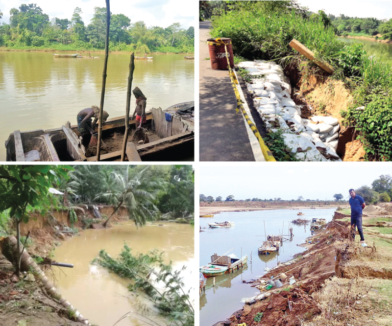
It is observed that divisional level government authorities are reluctant to take action against the river reservation encroachers in fear of unhealthy reactions from encroaching elements, inhabitants and local politicians.
But there are possibilities to introduce drastic land use policies for the river reservations to control the activities sabotaging the sustainability of a river, a national asset, preventing flooding, landslides, soil erosion, siltation of rivers, sea water intrusion drawdown of ground water causing the deterioration of river systems.