


 It was a thirst for adventure that prompted our sojourn to Ingiriya and its suburb, 60 kilometres Southeast of Colombo. It is one of the major towns in the Kalutara district, endowed with pleasant climate, picturesque rivers and valleys, dense jungles and secluded Buddhist hermitages.
Ingiriya is not a new place to me because I was born and bred in a village of Botalegama, one of the adjoining villages, Southeast of Ingiriya. As children, we enjoyed nature’s wonders during our childhood in the village, swimming in cool streams, playing in paddy fields, hiking mountains and eating wild fruits such as Maa Dan (big berries), jak fruit, Ataba (small type of wild mangoes) and embilla (bitter berries).
Picturesque countryside
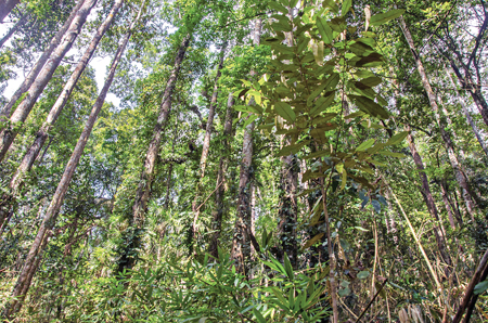
The Hora Forest Reservation on the Ingiriya-Meepe B285 road
Ingiriya sits across the Panadura-Nambapana-Ratnapura A 8 Highway, and is a routine waypoint on journeys to Ratnapura, Belihul Oya, and the hill country attractions of Haputale and Ella.
This highway is one of Sri Lanka’s best driving roads, and for most travellers, this is Ingiriya’s most remarkable feature. However, when one turns North, the picturesque countryside opens up, rising through gentle foothills to the Labugama Kalatuwawa Forest Reserve and the Seethawaka Wet Zone Botanical Garden, South of Avissawella.
Ingiriya receives a high rainfall, and its lush green jungle, fertile fields and plantations are partly a result of the wet climate. Many have heard much about the tea carpeted hills of the upper Central Highlands, but are surprised to find that in lowland Ingiriya, tea is the second-largest industry. Gentle footpaths to explore the area, lie amid rubber plantations which span over 5,000 acres along with tea plantations.
A narrow tributary of the Kalu Ganga flows South of Ingiriya, bisecting the A8 Highway. The meandering stream creates a shallow valley along which a relaxed walking of a few hours provides visitors an opportunity to experience a variety of terrain, both natural and sculpted by human cultivation. The stream offers ideal bathing spots, with shallow water and moderate currents.
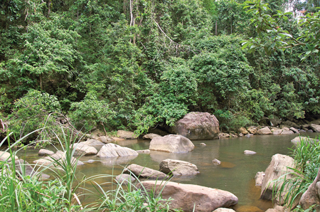
The Nachchimale stream, a tributary of the Kalu Ganga, flows beside the Madakada Aranya Senasanaya in Ingiriya
The most easily accessible bathing spot is at Nachchmale. The stream passes close to the Madakada Aranya Senasanay, a Buddhist hermitage with caves for meditation, and forms a series of curves, minor waterfalls, rapids and rock pools. Most of these can be reached by car, along the Ingiriya-Meepe B285 road, which heads Northeast from the town.
The Hora Forest Reservation skirts the Batugampola road to the left. From this road, several jungle trails lead to the reserve, winding between huge hora trees, which give this forest its name. A hora tree which can grow as tall as 60 metres, is a hardwood endemic to Sri Lanka; its dense timber is traditionally used for railway sleepers and bridge pilings. The thick layers of overhead foliage shadow the paths through the reservation.
To the South of Ingiriya, the Dombagaskanda or Bodhinagala road leads to the Kalu Ganga and the Bodhinagala Bird Sanctuary on its banks. The paths through the jungle are often used by the meditating bhikkhus of the Bodhinagala Aranya Senasanaya which lies deep inside the sanctuary. The monastic bhikkhus of the hermitage live in small abodes or ‘kuti’ of two hills, which they rarely leave.
Further up on Southeast of Ingiriya, the meandering Kalu Ganga is bridged near the pastoral village of Halwatura, one-time mighty state plantation with the crops of tea and rubber. It was managed by the British planters until the plantations were taken over by the Government.
Undulating mountains
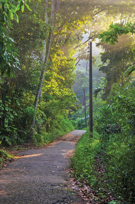
The rising sun casts soft rays on a village path near Ingiriya
Botalegama, another rustic village, six kilometres Southeast of Ingiriya has lush green undulating mountains after Halwatura. Most of the villagers are farmers whose livelihood is growing tea, rubber and paddy.
Kotigulkanda (the mountain of a leopard cave) lies on a verdant forested hill overlooking the valley of the Kalu Ganga, in the quiet village of Botalegama. From the summit of the mountain, one can see a breathtaking view of the surrounding countryside of the valley of the Kalu Ganga. Kotigulkanda is a steeped mountain and sheltered with a forest reserve. There is a natural rock cave on the slope of the mountain. One has to climb up around 1.5 kilometres of arduous trek through the jungle footpath to reach the cave where a meditating bhikkhu dwells. He is used to walking on ‘pindapatha’ to the village every morning for breakfast as he partakes of only one meal per day.
If you travel on A8 highway, Ingiriya is certainly worth a longer stopover than a cup of tea or breakfast. Salubrious as the climate is, the morning is probably the ideal time to walk along the jungle trails of the area.
There is much to discover for the intrepid traveller; from the local food to varied blends of tea, as well as birdlife. Ingiriya could be the perfect weekend getaway.